19. Mapping the Damon Family's Influence on Westvale
Calvin Carver Damon bought the mill from James Derby in 1834. Included in the purchase were the Bellows Factory Lot, as well as fifteen acres of land in South Acton. Damon's original acquisition was followed by a series of land purcases and homebuilding that created an even larger factory neighborhood in Westvale.
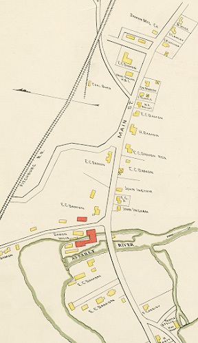
The 1852 Walling map of Concord shows C.C. Damon’s cotton and woolen mill standing out among the other mills and manufactories along the banks of the Assabet River. Two decades later the Beers Atlas devoted a detailed section to Westvale (shown above), in which the extent of the Damon family’s real estate holdings is clearly illustrated.
By 1875 they owned the mill complex, which included buildings on both sides of the river, additional property beyond the school building, three houselots, and a substantial lot of land on the opposite side of Main Street.
In 1889, the mortgaged mill was auctioned by the Middlesex Institution for Savings, ending the Damon family’s reign in Westvale. This section of the Walker map (published in that year) shows, in addition to property still called “Damon Mills,” six house lots, including two that had formerly belonged to the Brown family, residents of West Concord even longer than the Damons.
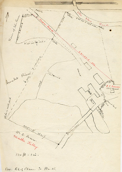
In addition to the Thoreau survey and printed maps of Damon property, a sketch or tracing prepared by lawyer Charles Hosmer Walcott to accompany his deed research also survives.